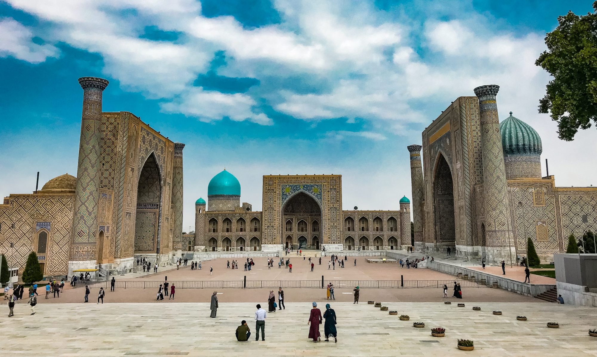
The Lycian Way (Likya Yolu in Turkish) is a long-distance hiking trail in South Turkey between Fethiye and Antalya. It follows the trade routes connecting cities of ancient Lycia. Lycia was an Anatolian nation and state, that existed from the 15th-16th century BC until the 5th century BC. It is also known for the Lycian League, the first such democratic union of independent city-states in history (2nd century BC). The route was known after the idea and book of Kate Clow and it became completely marked in 1999.
The trail is rich in natural beauty, diverse landscapes, culture, and history, reuniting all my interests for a good hike. That’s why I was interested for a while in walking as many sections possible of the route.
For preparation and planning, besides the book of Kate Clow, I would recommend the Wikivoyage post on the trail. Also the apps MapsMe, Wikiloc, or Comoot help for orientation during the hike.
Now let me present to you some of the sections in the Western part of the Lycian Way. About the Eastern part, I will write in a separate post.
Kayaköy – Ölüdeniz
I made this hike with my friends Ezgi and Ivar in May 2022. It is part of the section Fethiye – Ovacık, however, we adapted it to our availability and other points of interest in the area. So instead of walking from Fethiye we took a taxi and started the hike directly from the Ghost Town (the Turkish meaning of Kayaköy).
You might ask, why this place is called “Ghost Town”? Here is the sad history kept short. The town was very lively and prosperous before the First World War, inhabited mainly by Greeks, with a population of 6000 people, called Livissi. After the persecution of the Ottoman Empire against Christians during the war, the town was nearly depopulated, with Muslims refusing to settle there, because of the ghosts of Livisians massacred in 1915.
After the Independence War, the few remaining Greek inhabitants were forced to leave for Greece, so the town was emptied. The tragedy became complete with the earthquake of 1957 damaging the empty buildings.
Today the site is a museum and historical monument.
I was impressed by the alignment of the town on the hillside, dividing it into an upper and lower town. The Greek-style houses, the richness of churches and chapels, and course the breathtaking view from the highest chapel of the town are fascinating.
The town is not as empty as you might imagine. You can become friends with cats, dogs, goats, and turtles while you are walking its streets.


After having a rest and some delicious gözleme we started the more serious part of the hike. We descended in the pine forest with beautiful views over the bay of Ölüdeniz. The path is not particularly difficult, since it goes down mainly. After a 2-hour hike, you will reach the beach of Ölüdeniz.


After arriving at the beach, you still have energy and it´s not too late, you can take a cab or try your luck to hitchhike to the nearby cable car (“teleferik” in Turkish). It can take you up to 1900 m altitude on the top of Babadağ Mountain. The view is just stunning.


We then returned to our base near Kabak Beach, a very good spot if you prefer to stay in the middle of nature in bungalow-style accommodations. It is also located on the Lycian Way. From here you can visit the nearby Butterfly Valley (“Kelebekler Vadisi”) and other great spots to swim and sunbathe. Just be aware, that the Butterfly Valley can be flooded with party tourists during the day. They are coming with huge and loud pirate ships and literally invade the area. That´s maybe why you cannot spot any butterflies in the valley…


Patara Beach – Gelemiş
In September 2019 I set camp for a week in the little and quiet village of Gelemiş, next to the ruins of the ancient city of Patara. If you ever want to enjoy your holidays in this part of Turkey, I can warmly recommend the family-owned Flower Pension! Not just a nice green garden, terrace, and pool are waiting for you but a nice staff and delicious homemade dinner.
Although Patara Beach is considered a side branch of the Lycian Way, it has a lot to offer. The best you walk from Gelemiş village towards the river Eşen Çayı (the ancient river of Xanthos) between pomegranate trees and greenhouses full of tomatoes and other vegetables.
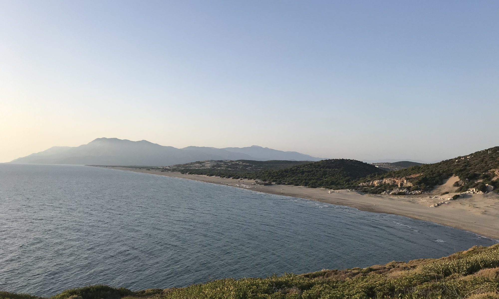
Once reach the stream, depending on the water level, you can cross to Kumluova Beach or just make a U-turn and walk back towards the ancient city of Patara on the beach. The beach is considered one of the longest and most beautiful ones in the world. It has an average of 500 m in width, very fine sand, and beautiful dunes. You feel sometimes that you are walking in a desert! Also, it is a nesting place for the Caretta Caretta sea turtles, which is why the beach is closed during the night. The whole area is put under protection.


After a 10 km walk on the beach, you will reach the ancient town of Patara, the capital of Lycia for a while in history. As I already mentioned, the Lycians built the first democratic representation institutions. Here you can admire the “parliament” of Lycia, the Assembly Hall. Other impressive monuments are the ancient theater, the lighthouse, the Gate of Hadrian, the main street, and temples. It is to be noted, that Nicholas of Myra (aka Santa Claus) was born at Patara in the 3rd century.


Gelemiş – Yeşilköy
The trail starts just in the middle of Gelemiş village and leads you along beautiful sceneries on the Mediterranean Sea. During the hike you will pass some narrow paths on the rock, beautiful pine tree forests, sheep, shepherds, and olive tree plantations. You might meet some local people guarding the animals or taking care of the olives.
The highlight of the hike is the ancient aqueduct of Delikkemer. Built about 2000 years ago, it had a length of around 20 km and supplied Patara with fresh water. The structure is very well preserved, and you can study the building blocks of the aqueduct. I was wondering how all this was assembled, knowing that one block is about 1 ton heavy!


A useful hint: be aware that on the last part of the hike, the path leads among thorn bushes, so make sure you wear long sleeves!
Once you reach the main road coming out of the forest, you can just hitchhike back to Gelemiş, if you set camp there, like I did it.
Korsan Koyu – Gelidonya Lighthouse
I did this section of the Lycian Way together with my friends Michaela and Ezgi, as a two-day escape from Antalya. We took a minibus from Antalya first to the little town of Kumluca. Here you can visit the ancient city of Rhodiapolis, located on a hill just above the town. It is recommendable to take a cab up to the archaeological site and then walk back to the city center. Here you can enjoy a delicious lunch with local ingredients since the region is famous for its vegetables.


After having a rest, we took a taxi to Korsan Bay (Korsan Koyu in Turkish) since there was no or not reliable public transportation service to our accommodation. My advice is to bargain the price of the ride and agree on it very clearly with the driver.
Once there, a little paradise on Earth is waiting for you. The infrastructure is very simple and in harmony with nature. There are only bungalow-style accommodation opportunities, rural-style cafes, and small restaurants. A beautiful little beach is also within walking distance. There you can take a bath or have a drink while watching the sunset. We slept at Korsan Camping – a camping and bungalow site with a very friendly staff. They have also a small menu and drinks for sale, so you don´t have to carry a lot of proviants with you.
The next day after a village-style Turkish breakfast we started our hike to the Gelidonya Lighthouse. Even if it is relatively at the beginning of the hike, you should not miss the juice bar which you will encounter on the right side just before entering the National Park. It is a lovely place with a very friendly owner, and delicious fresh fruits, juice, coffee, and tea. If you are lucky, you might get also handmade ice cream, made and delivered by a local old “usta” (master).
The way will lead you upwards revealing spectacular views until you finally reach the landmark of this section of the trail. The lighthouse was built in 1934 and is located on Cape Gelidonya at 227 meters. It is the highest lighthouse on the Turkish coast, offering a breathtaking view of a group of islands just in front of the cape (Beşadalar) and on the Mediterranean Sea.
Cape Gelidonya is the most dangerous place in the Gulf of Antalya due to countercurrents. In ancient times, many ships were dragged to the rocks and sank. That’s why the area turned into an underwater cemetery covered with shipwrecks over time. That explains the name of the cape, which in ancient Greek means “swallows” (Chelidonia).


The trail continues here until Adrasan. However, due to the very high temperatures we had and the difficulty level of the trail, we walked back to the campsite. We left the second part of the hike for the next time!